on the mark locators

Mapping Your Utility Lines with Sub-Foot GPS Precision

Do you have underground utility lines running under your yard, building, or other property? The only way to accurately know what’s there is to dig up the lines and walk the route, but that can be expensive and disruptive to your day-to-day life. Fortunately, there’s an easy solution in GPS utility mapping with sub-foot GPS precision that makes it possible to see what’s underground even before you dig.

Did you know that Google Earth features utility line mapping? Now you can easily see your lines on an aerial map, allowing your customers to find your utility services quickly and efficiently. You can now take Google Earth’s accuracy to the next level by using the geode sub-foot GPS unit with RD8100/8200 Receiver with Google Earth Utility Line Mapping. Now anyone can easily map their utility lines with sub-foot GPS precision and share them as a Google Earth file. Read on to learn more about how this combination of products can help you attract new business with sub-foot GPS precision maps!
utility mapping

What Is GPS Utility Mapping?

If you have a job site or project involving digging, you need to know where all your utility lines are before starting. The last thing you want is to accidentally dig up a water line and flood your house, or worse. Thankfully, there there’s underground utility mapping software\>. Utilizing GPS technology lets you map out your utility lines precisely, so it’s easy to avoid them when digging for whatever reason.

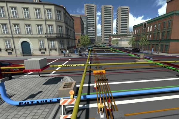
Finding underground utilities can be tricky, but GPS utility maps ensure that all necessary information about underground utilities is available via digital means in an easy-to-navigate format. Kit includes Geode GPS unit and accessories. Subsurface Maps App and RD8100/8200 were purchased separately.

How Does GPS Support Asset Management?

You can now accurately map utility lines buried underground, giving you full control over their location and minimizing maintenance costs. All it takes is an RD8100/8200 surface laser scanner paired with Geode GPS to create sub-foot GPS precision maps of your asset’s precise position. This high level of accuracy is easy to achieve because all you have to do is follow these steps: First, create a UTM survey using Geode GPS. Next, set up your scanner on a stable surface that’s not affected by wind or movement—the key here is having total stability for collecting data. Lastly, run your raster program of choice on top of your survey data and begin scanning! It is that simple.

How Accurate Are GPS Surveys?

If you’re, you’re mapping your utility lines, and accuracy is key. One of our favorite GPS systems for underground mapping is also one of our most accurate. It’s called a Geode, and it was designed specifically for underground surveying. The Geode integrates a high-accuracy GPS antenna into an extremely rugged package that can operate hands-free from inside a vehicle.

When paired with RD8100 or RD8200 receiver, they’ll not only provide sub-foot GPS precision but also deliver RTK navigation performance in seconds—enabling users to move across large areas quickly. In other words: They survey fast and accurately! Contact us today to learn more about how a system like this could work for you. We have a few different options available depending on what application is right for you.

What Should I Consider When Purchasing a GPS System?

A lot of factors play into whether or not a GPS is right for you. These factors include your budget, how much precision you need, and what type of map you create. The goal here is to help you narrow down which GPS device will work best for your situation. If mapping utility lines is something that interests you, keep reading. We’ll cover what to look for in a GPS so that you can start creating custom maps in no time. This guide will also talk about the RD8100/8200 Geode system, including why it’s an ideal choice for sub-foot GPS mappers. To get started, let’s take a look at some GPS systems on the market today.

Which GPS Hardware Is Right For Me?

Geode enables surveying professionals to map their utility lines with sub-foot GPS precision, but there are many options out there. Depending on your situation, you might be interested in a handheld GPS unit. This handheld GPS unit integrates aerial photos and maps into your field data or a larger fixed device used as part of a data collection program. No matter what you’re you’re looking for, and we have something for you. To help you figure out which is right for you, here’s an overview of Geode and some other industry favorites.

When Should I Map My Utility Lines?

How Long Does It Take to Map My Utility Lines?

Mapping utility lines takes time, but not nearly as long as digging up everything underground. While it can vary based on where you’re at in the survey process, mapping utilities should take less than half of the total project time. That’s means if you’re spending eight hours mapping utilities across four miles of roadways over two days, it will take approximately 15 minutes per mile to survey via GPS positioning technology.

Schedule Appointment

Fill out the form below, and we will be in touch shortly.
Contact Information