Ground Penetrating Radar for Utility Locating: How the Technology Works
Before starting any excavation, construction, landscaping, or infrastructure project, it is important to understand what lies beneath the ground. Underground utilities such as water pipes, sewer lines, electrical conduits, gas lines, and telecommunications cables can create serious challenges when their locations are unknown. Accidentally striking these utilities can cause property damage, service interruptions, project delays, and safety hazards. Ground penetrating radar (GPR) is a valuable technology that helps professionals investigate subsurface conditions and identify potential underground features before ground-disturbing work begins.
Ground penetrating radar utility locating uses electromagnetic signals to detect changes in underground materials and structures. Unlike traditional locating methods that primarily rely on conductive utilities, GPR can help identify certain nonmetallic objects and subsurface features under suitable conditions. This makes the technology particularly useful when project teams need additional information about buried infrastructure that may not be easily detected using conventional equipment alone.
However, GPR is not simply a matter of scanning the ground and immediately knowing what lies beneath it. Successful detection depends on several factors, including soil composition, moisture levels, target depth, object size, equipment settings, and the operator's experience interpreting radar data. Understanding how the technology works helps property owners, contractors, engineers, and construction managers make better-informed decisions before excavation.
At On The Mark Locaters, understanding subsurface conditions is an important part of preparing for construction and excavation projects. By recognizing the capabilities and limitations of GPR scanning, project teams can better understand potential underground obstacles and plan their work with greater confidence.
1: What Is Ground Penetrating Radar for Utility Locating?
Ground penetrating radar is a nondestructive investigation technology that uses electromagnetic energy to examine materials beneath a surface. In utility locating, the equipment sends radar signals into the ground and records the signals that return after encountering boundaries between materials with different electrical properties.
These reflections can reveal patterns associated with buried utilities, changes in soil composition, voids, concrete structures, and other subsurface features. Trained professionals examine the resulting radar data to determine whether a signal may correspond to a utility or another underground object.
Unlike methods that depend on a metal conductor or an accessible connection point, ground penetrating radar for utility locating can sometimes identify nonmetallic infrastructure, including plastic pipes and certain nonconductive conduits. This capability is particularly useful when investigating areas where traditional electromagnetic locating equipment may provide limited information.
What Types of Underground Features Can GPR Help Identify?
Depending on the site conditions and equipment used, GPR may help locate or investigate:
Plastic and metallic pipes.
Electrical conduits and telecommunications pathways.
Buried concrete structures and foundations.
Subsurface voids and material changes.
Underground tanks and other buried objects.
Certain drainage systems and abandoned infrastructure.
The effectiveness of detection varies considerably between sites. For example, a utility that produces a clear radar reflection in dry, sandy soil may be difficult to identify in wet, electrically conductive clay.
It is also important to understand that GPR does not automatically determine the exact purpose of every buried object. A radar response may indicate a possible pipe or conduit, but additional investigation or comparison with other locating methods may be necessary to establish its identity.
For this reason, GPR is most effective when used as part of a professional utility investigation process rather than treated as a standalone guarantee of underground utility identification.
2: How Does GPR Equipment Send and Receive Signals?
Understanding the basic operating process helps explain why GPR is a useful tool for investigating underground conditions. The technology relies on the transmission of electromagnetic pulses, the reflection of energy from subsurface boundaries, and the interpretation of the signals received by the equipment.
Step 1: Transmitting Electromagnetic Signals
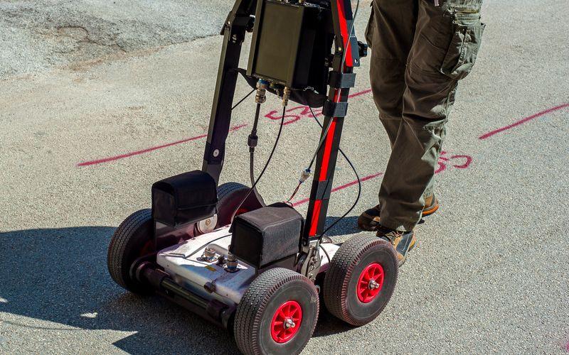
A GPR system typically includes a control unit, a transmitting antenna, a receiving antenna, and a display or data collection system. Depending on the equipment design, the transmitting and receiving functions may be integrated into the same antenna assembly.
As the operator moves the equipment across the ground, the transmitter sends short electromagnetic pulses into the subsurface. These pulses travel through the ground until they encounter materials or objects that have different electromagnetic properties.
The frequency of the antenna influences the investigation. Higher-frequency antennas generally provide better resolution for shallow features, while lower-frequency antennas can offer greater penetration in suitable conditions, often with reduced detail.
Selecting the appropriate equipment is therefore an important part of effective GPR utility locating.
Step 2: Signals Encounter Underground Materials
When electromagnetic energy travels through the ground, it may encounter boundaries between soil layers, buried pipes, concrete, rocks, or other materials. Some of the energy continues through the material, while some may be reflected toward the surface.
The amount of reflected energy depends on differences in the materials' dielectric properties and electrical conductivity, as well as the target's shape, size, orientation, and depth.
For example, a buried pipe may produce a recognizable reflection because its material and surrounding soil respond differently to the radar signal. However, not every pipe creates a strong or easily distinguishable response.
Step 3: The Receiver Records Returning Reflections
The receiving antenna detects returning electromagnetic signals and sends the information to the system's recording unit. The equipment measures the signals' timing and characteristics, creating data that can be displayed as radar traces or profiles.
The time taken for a signal to travel into the ground and return can help professionals estimate the depth of a potential target. However, depth estimates depend on the assumed or measured speed of electromagnetic waves through the material.
If the subsurface properties are not accurately understood, calculated depths may be uncertain. This is one reason why experienced operators evaluate site conditions and interpret radar data carefully.
Step 4: Radar Data Reveals Potential Underground Features
As scanning continues, the system collects multiple measurements along a survey path. These measurements can be combined into a radar profile showing variations in the returning signals.
The resulting profile may reveal curved patterns, strong reflections, or changes in signal strength that suggest the presence of buried objects. Professionals assess these patterns alongside site information and observations from other locating methods.
The technology does not directly produce a perfect picture of every underground utility. Instead, it provides data that trained professionals interpret to develop a more informed understanding of subsurface conditions.
3: The GPR Scanning Process for Underground Utility Detection
Successful gpr utility locating requires more than operating the equipment. A structured scanning process helps improve coverage, organize findings, and reduce the likelihood of overlooking potential underground features.
Step 1: Review the Project Area and Existing Records
Before scanning begins, the locating team should review available utility drawings, construction plans, previous survey information, and other relevant records.
These documents can identify known utility corridors and areas where additional investigation may be necessary. However, existing records may be incomplete, outdated, or inaccurate, so they should be treated as supporting information rather than definitive proof of underground conditions.
The team should also understand the proposed excavation area, planned trench routes, access restrictions, and the types of infrastructure likely to be present.
Step 2: Assess Surface and Soil Conditions
GPR performance is strongly influenced by the ground through which electromagnetic signals travel. Soil type, moisture, conductivity, surface conditions, and the presence of buried debris can all affect the quality of the results.
Before scanning, professionals consider whether the selected equipment and scanning approach are appropriate for the site. They may also identify obstacles such as uneven surfaces, reinforced concrete, standing water, or restricted access that could affect data collection.
This preliminary assessment helps establish realistic expectations for the investigation.
Step 3: Scan the Ground in Planned Patterns
The operator moves the GPR antenna across the designated area, collecting measurements along planned survey lines. Scanning in multiple directions can help reveal underground features that might not be obvious from a single pass.
For example, a buried pipe crossing one survey line may create a different response from a pipe running parallel to it. A grid-based scanning pattern can help professionals identify these relationships and build a more complete picture of the area.
The survey spacing and coverage should reflect the project's objectives, expected utility layout, and site conditions.
Step 4: Interpret the Collected Radar Data
After or during scanning, the operator reviews the recorded radar profiles to identify potential targets and distinguish meaningful patterns from background signals or interference.
Some underground objects create clear, recognizable responses, while others may be obscured by surrounding materials or overlapping reflections. Experienced interpretation is essential because a radar anomaly does not automatically confirm the presence, identity, or depth of a utility.
Where appropriate, professionals compare the findings with electromagnetic locating results, utility records, visible infrastructure, and other available evidence.
Step 5: Mark Findings and Communicate Limitations
Potential underground features can be documented and marked in accordance with the project's requirements and applicable procedures. Findings may include estimated positions, depth information where supported, areas requiring further investigation, and limitations affecting confidence in the results.
Clear communication allows contractors and project managers to incorporate the findings into excavation planning.
At On The Mark Locaters, understanding how underground detection methods contribute to project planning can help teams recognize the importance of investigating subsurface conditions before digging. A professional locating process provides useful information for making better-informed decisions about the work ahead.
4: How Professionals Interpret GPR Radar Data
Collecting radar data is only one part of a successful survey. The information must also be interpreted correctly to identify meaningful underground patterns and understand the limits of what the equipment can reveal.
Recognizing Hyperbolas and Other Radar Patterns
One common feature in GPR profiles is a hyperbola-shaped response. This pattern can appear when the antenna passes over a localized object, such as a pipe or another buried feature.
As the antenna approaches the object, moves across it, and continues away, the recorded travel times change. These changes can create the characteristic curved pattern visible in the radar profile.
However, a hyperbola does not automatically confirm that the target is a pipe. Rocks, isolated objects, and other subsurface features may create similar responses. Professionals evaluate the shape, continuity, depth, surrounding signals, and relationship to adjacent scan lines before drawing conclusions.
Evaluating Signal Strength and Continuity
A potential utility may produce a reflection that continues across several survey lines or appears in a consistent location as scanning progresses. This continuity can help distinguish a possible linear feature from an isolated anomaly.
Signal strength also provides useful information, but a strong reflection does not necessarily indicate a large utility, and a weak response does not mean that no utility exists.
The material surrounding the target, the antenna frequency, the object's orientation, and the depth of the feature can all influence the recorded signal.
Estimating the Depth of Underground Features
GPR systems measure signal travel time rather than directly measuring depth. To estimate the depth of a target, the operator needs an appropriate estimate of the electromagnetic wave velocity through the ground.
Velocity can vary between different soils and materials, so assumptions that work well in one location may not be suitable elsewhere. Where appropriate, calibration or additional measurements can help improve depth estimates.
Depth information should therefore be interpreted with care, particularly when excavation activities require precise clearance around existing infrastructure.
Combining GPR with Other Locating Methods
GPR is valuable because it can provide information that complements other utility locating technologies. Electromagnetic locating equipment, for example, is particularly useful for tracing conductive utilities or utilities that can be accessed through suitable connection points.
GPR may help investigate certain nonmetallic pipes, conduits, and other buried features that do not respond to conventional electromagnetic methods.
When the site conditions and project requirements allow, using multiple methods can provide a more complete understanding of underground infrastructure. Any conflicting results should be investigated rather than resolved through assumptions.
5: Factors That Affect GPR Utility Locating Accuracy
Although GPR can be a powerful investigation tool, its performance is not identical at every site. Understanding its limitations helps project teams establish realistic expectations and determine when additional investigation may be necessary.
Soil Composition and Electrical Conductivity
Soil composition is one of the most important factors affecting radar penetration. Dry sand and some granular materials may allow electromagnetic signals to travel relatively effectively through the ground.
Clay-rich soils, especially those with high electrical conductivity, can absorb or attenuate electromagnetic energy more strongly. This can reduce the depth at which useful reflections can be detected.
As a result, a survey that produces clear results in one area may offer limited penetration in another, even when the equipment and operator are the same.
Moisture Levels and Ground Conditions
Water content can change the electrical properties of soil and influence how electromagnetic waves travel through it. Increased moisture may improve contrast in some circumstances, but wet or conductive ground can also increase signal attenuation.
Recent rainfall, groundwater conditions, and variations in soil moisture across the site can therefore affect scanning results.
Professionals need to consider these conditions when choosing equipment, assessing potential targets, and determining whether additional locating methods may be appropriate.
Utility Depth, Size, and Material
Deeper utilities generally produce weaker signals because electromagnetic energy loses strength as it travels through the ground and back to the receiver. Small objects may also be harder to detect than larger targets, particularly when they are surrounded by materials with similar electromagnetic properties.
The material of the utility matters as well. Both metallic and nonmetallic objects may produce detectable reflections, but detection depends on the contrast between the object and the surrounding material.
A plastic pipe may be detectable in suitable conditions but difficult to distinguish in other environments. Therefore, GPR should not be considered a universal solution for locating every buried utility.
Surface Interference and Congested Underground Areas
Reinforced concrete, metal objects near the surface, construction debris, and dense networks of underground utilities can complicate radar interpretation.
When multiple objects are close together, their reflections may overlap, making it difficult to determine the precise location or identity of individual features. Uneven terrain and obstacles can also limit access or affect consistent scanning.
A careful survey plan, appropriate equipment settings, and experienced data interpretation can help manage these challenges, although some uncertainties may remain.
Operator Experience and Equipment Selection
The quality of GPR results depends on selecting suitable equipment and understanding the data it produces. Antenna frequency, scanning speed, survey spacing, system settings, and interpretation techniques all influence the usefulness of the findings.
Experienced professionals recognize potential sources of interference and understand when a radar response requires further investigation.
For project teams, this means that choosing a qualified locating provider is just as important as selecting the technology. Reliable decisions depend on both the equipment and the professional expertise used to interpret its results.
6: Why Professional GPR Utility Locating Matters Before Digging
Underground utility detection is an important part of planning construction, excavation, landscaping, and infrastructure projects. Professional GPR scanning can help project teams identify potential underground features and investigate areas where existing utility information may be incomplete.
Reduce the Risk of Utility Damage
Excavation can damage water lines, sewer systems, electrical infrastructure, gas pipelines, and communications cables when their locations are unknown or incorrectly documented.
GPR scanning can provide additional information about possible underground obstacles before work begins. This helps contractors identify areas that may require closer investigation and adjust their plans when necessary.
However, GPR does not guarantee that every buried utility will be detected. Appropriate utility locating procedures, required notifications, and verification practices must still be followed.
Support Better Project Planning
Unexpected underground infrastructure can force construction teams to change excavation routes, reschedule activities, or arrange additional inspections. Identifying potential obstacles early can help project managers plan work more efficiently.
GPR findings may help teams evaluate proposed trench locations, assess areas around existing structures, and identify places where additional investigation is needed.
This information supports more informed planning and can reduce the likelihood of avoidable disruptions.
Help Protect Workers and the Public
Damaged underground infrastructure can create significant hazards, including electrical exposure, gas releases, flooding, and disruptions to essential services.
Professional utility locating helps teams recognize potential risks before excavation begins. When combined with appropriate safety procedures, utility records, and verification methods, GPR scanning can contribute to a more informed approach to managing underground hazards.
Complement Utility Records and Other Survey Methods
Utility records are an important starting point, but they may not reflect every change made to a site over time. Previous repairs, undocumented installations, abandoned lines, and inaccurate drawings can leave gaps in available information.
GPR provides an additional way to investigate the subsurface, helping professionals compare physical evidence with existing documentation.
Combining records research, electromagnetic locating, GPR, and other suitable investigation techniques can improve the overall understanding of underground conditions.
Work with On The Mark Locaters
Choosing the right locating approach depends on the project area, expected underground infrastructure, ground conditions, and the information needed before excavation.
On The Mark Locaters supports projects involving utility locating, ground penetrating radar (GPR), subsurface utility engineering (SUE), and related investigation services across Maryland, Pennsylvania, Delaware, New Jersey, Washington, DC, and Virginia.
By considering the project requirements and the capabilities of different detection methods, project teams can make better-informed decisions about subsurface investigation before breaking ground.
Whether the work involves construction, trenching, landscaping, or infrastructure improvements, professional locating services can help identify potential underground conflicts and determine where further verification may be needed.
Conclusion
Ground penetrating radar is a valuable technology for investigating underground conditions and identifying potential buried features before excavation. By transmitting electromagnetic signals into the ground and analyzing returning reflections, GPR equipment provides information that trained professionals can use to investigate possible pipes, conduits, buried structures, and other subsurface objects.
However, successful ground penetrating radar utility locating depends on more than the equipment itself. Soil composition, moisture, electrical conductivity, utility depth, target characteristics, and operator experience all influence the quality of the results. Understanding these factors helps project teams recognize the technology's capabilities and limitations.
Professional gpr utility locating and gpr scanning can complement existing utility records and other detection methods, giving contractors, engineers, and property owners additional information for planning excavation and reducing the risk of unexpected underground conflicts. Because no single detection method can guarantee identification of every buried utility, a comprehensive approach and appropriate verification remain essential.
At On The Mark Locaters, we understand the importance of investigating subsurface conditions before construction and ground-disturbing work begins. Our utility locating, GPR, and subsurface investigation services help project teams better understand potential underground obstacles and make informed decisions about their next steps.
Planning an excavation or construction project? Contact On The Mark Locaters to discuss your underground utility locating and GPR scanning needs. Taking the time to investigate what lies beneath the surface can help you prepare for your project with greater confidence and reduce avoidable risks before digging begins.