
UTILITY MAPPING
Home » Utility Mapping
Util-locate has been providing effective subsurface Utility maps since 2001
THE IMPORTANCE OF UTILITY MAPPING
In addition to the on-site communication received from our Project Managers, our clients receive filed markings in the form of paint, pin flags, stakes or any other method as directed by the client. Our PMs are trained to make all of their field markings to be clear, accurate and understandable for anyone who may view them.
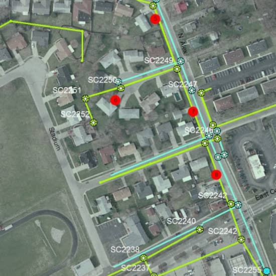
The Deliverables Department is able to create a CAD file that documents our results. This allows clients such as contractors, engineers, and owners to create or update as-built drawings for preplanning, utility avoidance, or to document site history and site changes and can be exported to a variety of CAD and GIS systems.
We’re On Call 24/7 to React Promptly to Your Service Needs, Don’t Hesitate to Call.
What are the benefits of Underground Utility Mapping?
Reduce project planning down time
Comply with safety regulations and requirements
Minimize risk
Avoid the unexpected
Gain confidence before excavation
Safety is a click away
Underground Utility Mapping
We has been providing effective subsurface Utility maps since 2001, having developed reputable solutions for a wide range of clients across Southern California. If you need a fully comprehensive map of the surveyed utilities that may cause conflict in design or construction, our team can provide you with the solutions you need. We take the worry of working around underground utilities away by giving you the confidence to plan, design and manage underground utilities. We are able to adapt to site changing conditions, and work through any stage of design or construction by combining latest technology, field expertise and non-destructive digging/Utility Potholing.
Industry Partnership

gpr concrete scanning

gpr concrete scanning

gpr concrete scanning

gpr concrete scanning

gpr concrete scanning
gpr concrete scanning

© All rights reserved 2021 | On The Mark Locators