Subsurface Utility Locating Methods: How Professionals Find Hidden Underground Lines
Underground utility lines play an essential role in keeping homes, businesses, and public infrastructure operating smoothly. Water pipes, gas lines, electrical cables, telecommunications networks, sewer systems, and other buried utilities support everyday activities. However, because these systems are hidden beneath the ground, identifying their exact locations before excavation or construction can be challenging. Striking an underground utility can cause costly project delays, service interruptions, property damage, and serious safety hazards.
This is where subsurface utility locating becomes an important part of construction planning and site preparation. Professional utility locating helps project teams identify and assess underground infrastructure before digging, trenching, drilling, landscaping, or performing other ground-disturbing activities. Instead of relying on a single detection technique, experienced professionals use different methods to locate buried utilities based on the materials involved, site conditions, and project requirements.
Common approaches include electromagnetic detection, ground-penetrating radar (GPR), surface feature surveys, and existing utility records research. Each method provides different information, and combining multiple techniques can improve the overall understanding of underground conditions.
At On The Mark Locaters, understanding the importance of accurate underground utility identification helps contractors, property owners, engineers, and project managers make more informed decisions before excavation begins. Learning how these locating methods work can help project teams recognize potential risks and plan ground-disturbing work more effectively.
Understanding Subsurface Utility Locating and Why It Matters
Subsurface utility locating is the process of identifying the presence and approximate position of underground utility infrastructure using specialized equipment, field observations, available records, and professional assessment. Its purpose is to help project teams understand what may be buried beneath a work area before they disturb the ground.
Underground utilities are not always installed in straight lines or at consistent depths. Over time, repairs, upgrades, new installations, and changes to surrounding properties can make underground conditions more complicated. Existing records may not reflect every modification, and some older utility installations may have incomplete documentation.
Professional locating provides valuable information that supports safer excavation planning. It helps construction teams identify potential conflicts between planned work and existing infrastructure, allowing them to adjust excavation routes, installation plans, or work procedures when necessary.
Common Underground Utilities Professionals Locate
Subsurface utility locating may involve identifying several types of buried infrastructure, including:
Electrical lines: Power cables supplying residential, commercial, and industrial properties.
Natural gas lines: Underground piping that transports gas to buildings and equipment.
Water lines: Pipes that supply drinking water and other water services.
Sewer and stormwater systems: Underground pipes and drainage structures that manage wastewater and surface runoff.
Telecommunications lines: Fiber-optic cables, telephone lines, and communication infrastructure.
Other buried infrastructure: Depending on the site, locating efforts may also consider abandoned utilities, private service lines, and unidentified underground features.
Different utilities require different detection approaches. For example, a metallic electrical cable may be detectable with electromagnetic equipment, while a nonmetallic plastic pipe may require ground-penetrating radar, tracer technology, records research, or another suitable method.
Why Utility Identification Should Happen Before Excavation
Underground utility identification is especially important before activities such as foundation construction, roadwork, directional drilling, fence installation, landscaping, and trenching.
Locating potential underground conflicts early helps teams reduce uncertainty, protect workers, minimize unexpected service disruptions, and avoid unnecessary repair expenses. It can also support better project scheduling by reducing the likelihood of delays caused by unidentified infrastructure.
However, no locating method can guarantee that every buried utility will be detected. The accuracy of the results depends on the available information, the equipment used, site conditions, and the characteristics of the underground infrastructure.
Electromagnetic Detection for Locating Conductive Utilities
Electromagnetic detection is one of the most widely used methods for identifying underground utilities containing conductive materials. It is particularly useful for locating metallic pipes, electrical conductors, and certain telecommunications cables.
The method uses electromagnetic signals to help a trained operator detect and trace a buried conductive utility. Depending on the equipment and locating approach, the signal may originate from an existing energized conductor or be introduced using a transmitter.
How Electromagnetic Utility Locating Works
There are two common approaches to electromagnetic detection: passive locating and active locating.
Passive locating involves detecting existing signals associated with underground infrastructure. For example, certain electrical lines produce detectable electromagnetic fields. Some communication cables may also carry detectable signals. Passive locating can help identify potential utility routes, but not every buried line produces a detectable signal.
Active locating involves applying a controlled signal to a conductive utility using a transmitter. This can be accomplished through a direct connection to an accessible conductor or through an induction method, depending on the equipment and site conditions. A compatible receiver then detects the resulting signal, helping the operator trace the utility's route.
Professional operators may use different frequencies and connection techniques to improve detection, reduce interference, and distinguish between potential utility paths.
Advantages and Limitations of Electromagnetic Detection
Electromagnetic locating is useful because it can efficiently trace conductive utilities across a site. It can help identify the route of metallic water pipes, electrical cables, and other detectable conductors without requiring extensive excavation.
However, this technique has limitations. Nonconductive plastic pipes, unmarked fiber-optic lines without detectable metallic components, and other nonmetallic infrastructure may not respond directly to electromagnetic detection.
Signal interference can also occur when utilities run close together or when multiple conductive structures are present. In some cases, the detected signal may transfer to another conductor, creating uncertainty about the actual utility route.
For these reasons, electromagnetic detection is often most effective when combined with other locating techniques. Experienced professionals evaluate signal quality, surrounding conditions, and the expected type of utility before interpreting the results.
Ground-Penetrating Radar (GPR) for Detecting Buried Infrastructure
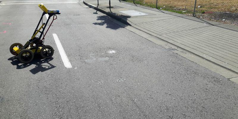
Ground-penetrating radar, commonly known as GPR, is another important method used in subsurface utility locating. Unlike electromagnetic equipment that depends on detecting signals associated with conductive utilities, GPR uses radar pulses to identify changes in underground material properties.
This technology can help locate certain nonmetallic utilities, buried structures, and other subsurface features that may not be detectable using electromagnetic methods alone.
How Ground-Penetrating Radar Works
A GPR system transmits high-frequency electromagnetic pulses into the ground through an antenna. When these pulses encounter boundaries between materials with different electrical properties, some of the energy reflects toward the antenna.
The equipment records these returning signals and displays them as data that a trained operator interprets. Depending on the survey conditions, the resulting patterns may indicate buried pipes, conduits, concrete structures, voids, or other underground features.
Operators typically move the GPR equipment along planned survey lines or a grid to examine the target area. Reviewing multiple passes can help clarify the location and continuity of potential underground features.
Can GPR Locate Nonmetallic Utilities?
One of the main advantages of GPR is its ability to detect certain nonmetallic objects under suitable conditions. Plastic water pipes, nonmetallic conduits, and other buried infrastructure may produce detectable radar reflections when there is sufficient contrast between the object and surrounding soil.
However, detection is not guaranteed. GPR performance depends on several factors, including soil composition, moisture content, utility depth, target size, antenna frequency, and the surrounding materials.
For example, clay-rich or highly conductive soils can significantly reduce radar penetration. Wet or saline conditions may also affect signal performance. Small utilities or objects with limited contrast against the surrounding soil can be difficult to distinguish.
GPR data can also contain reflections from rocks, roots, changes in soil layers, and unrelated buried objects. This makes professional interpretation essential.
Why GPR Complements Other Locating Methods
GPR is especially valuable when a site contains a mixture of metallic and nonmetallic utilities or when records suggest the presence of infrastructure that cannot be traced electromagnetically.
Rather than treating every radar reflection as a confirmed utility, experienced operators evaluate the data alongside surface observations, utility records, and electromagnetic findings. Using these sources together can improve the overall interpretation of underground conditions.
For contractors and property owners, combining GPR with other appropriate detection methods can provide a more complete picture of potential excavation hazards.
Surface Feature Surveys and Visual Site Inspections
Not every utility locating method relies on specialized electronic equipment. Surface feature surveys and visual inspections also provide important clues about underground infrastructure.
Many buried utilities connect to visible structures at ground level. Identifying these features can help professionals understand the likely arrangement of underground systems and determine where additional investigation may be necessary.
Identifying Visible Signs of Underground Utilities
During a surface survey, professionals may inspect a site for features such as:
Utility access covers and manholes.
Water meter boxes and valve covers.
Fire hydrants and visible water infrastructure.
Electrical cabinets and utility poles.
Communication boxes and telecommunications pedestals.
Drainage inlets, catch basins, and sewer access points.
Marked utility routes, service entrances, and visible pipe connections.
These features can indicate the presence of underground systems and provide reference points for further investigation.
For example, a series of manholes may suggest the route of a sewer network, while a water meter box can help identify the location of a service connection. Utility cabinets and visible conduit entrances may provide additional clues about electrical or communication infrastructure.
How Surface Surveys Support Accurate Locating
Surface observations help operators plan their survey coverage and identify areas that deserve closer attention. They can also help compare detected utility routes with visible infrastructure.
Suppose a proposed trench runs near a utility cabinet and several access covers. A surface inspection may reveal potential underground conflicts before the locating survey begins. The team can then prioritize those areas for electromagnetic detection, GPR, or additional investigation.
Surface feature surveys are particularly helpful when combined with existing site plans and utility records. Together, these information sources can provide a clearer understanding of how different utility systems may connect.
Limitations of Visual Inspections
Although surface features provide useful information, they cannot establish the exact location or depth of every buried utility.
Some underground systems have no obvious surface indicators. Others may have access points that were relocated, covered, or removed during construction. A visible feature may also connect to infrastructure that follows an unexpected route.
For this reason, visual inspection should be treated as one part of a broader locating process rather than a replacement for suitable detection methods.
Existing Utility Records Research and Underground Mapping
Existing utility records are another valuable resource in subsurface utility locating. These records may include utility maps, construction drawings, as-built plans, engineering documents, municipal records, and information supplied by utility owners.
Reviewing available documentation helps professionals understand the known history of a site and identify areas where underground infrastructure may be present.
What Utility Records Can Reveal
Utility records may provide information about the approximate routes, sizes, materials, and intended locations of buried pipes, cables, conduits, and other infrastructure.
Construction drawings may also show utility corridors, connection points, service entrances, and relationships between different underground systems.
This information helps locating professionals develop a preliminary understanding of the site before conducting fieldwork. It can also help identify discrepancies between planned excavation and documented utility routes.
However, records vary in quality and completeness. Older documents may reflect original installation plans rather than the infrastructure's current condition. Subsequent repairs, undocumented changes, and abandoned lines may not appear in available records.
Why Records Must Be Verified in the Field
Utility maps should not automatically be treated as proof of the exact location of buried infrastructure. A line shown on a drawing may have shifted from its intended position, or the document may lack reliable depth information.
Field verification helps determine whether documented utility routes are consistent with actual site conditions. Professionals can compare record information with electromagnetic readings, GPR findings, surface features, and other available evidence.
When discrepancies appear, additional investigation may be necessary before excavation proceeds.
Combining Records Research With Subsurface Utility Locating
Records research is most valuable when it supports, rather than replaces, field detection.
For example, existing plans may indicate a nonmetallic water line crossing a proposed construction area. An operator can use that information to select suitable detection techniques, establish survey priorities, and investigate the suspected route.
Similarly, records showing multiple utilities in a narrow corridor can alert the project team to potential signal interference or congestion.
By combining documented information with field observations, professionals can make more informed decisions about where utilities may be located and where uncertainty remains.
Choosing the Right Locating Methods for Different Site Conditions
There is no single utility locating method that works equally well for every underground environment. The most suitable approach depends on the types of utilities present, the materials involved, the expected depth, surrounding soil conditions, and the level of confidence required for the project.
Experienced locating professionals evaluate these factors before selecting equipment and planning their surveys.
Matching Detection Methods to Utility Types
Different locating methods offer different advantages.
Metallic pipes and conductive cables: Electromagnetic detection can help trace the utility route when a suitable signal is available.
Plastic pipes and nonmetallic conduits: GPR may help identify these utilities when soil and target conditions allow adequate detection.
Complex or congested utility corridors: Combining electromagnetic detection, GPR, surface inspections, and records research can help distinguish potential utility routes.
Sites with incomplete documentation: Records research, surface observations, and field detection can be used together to investigate undocumented infrastructure.
Areas with challenging soil conditions: Professionals may need to adjust equipment settings, use alternative techniques, or communicate limitations when reliable detection is difficult.
The objective is not simply to collect readings. It is to interpret the available evidence and develop a useful understanding of underground conditions before work begins.
Why Multiple Methods Can Improve Results
Using multiple locating techniques can reduce dependence on any single source of information. For instance, electromagnetic detection may identify a conductive cable, while GPR may reveal nearby nonmetallic features that electromagnetic equipment cannot detect directly.
Surface inspections can help explain where these features may connect, and existing records can provide additional context about the expected utility layout.
When findings from different methods agree, confidence in the interpretation may improve. When they conflict, the differences can highlight areas that require further investigation.
However, multiple methods do not eliminate all uncertainty. Some utilities may remain undetected, particularly when conditions are unfavorable or the infrastructure has unusual characteristics.
The Importance of Professional Interpretation
Utility locating requires more than operating equipment. Professionals must understand how signals behave, recognize possible interference, interpret radar responses, and distinguish confirmed observations from uncertain findings.
A professional locating process may include reviewing project plans, examining the site, researching available records, selecting suitable detection equipment, conducting field surveys, marking identified utilities, and documenting relevant limitations.
Where excavation is planned near a critical or uncertain utility, additional verification may be necessary. Depending on local requirements and site conditions, this may include carefully controlled exposure or other approved verification procedures.
Contractors should also follow applicable utility notification requirements, excavation safety practices, and local regulations. Surface markings and locating reports are important planning tools, but they should not be treated as a guarantee that every underground hazard has been identified.
By selecting appropriate techniques and interpreting the results carefully, experienced professionals help project teams make better-informed decisions before disturbing the ground.
Conclusion
Underground infrastructure can create significant challenges for construction, excavation, landscaping, and infrastructure improvement projects. Because buried utilities are not always visible or accurately documented, identifying them before ground-disturbing work is an essential part of responsible project planning.
Electromagnetic detection helps locate many conductive utilities, while ground-penetrating radar can identify certain nonmetallic infrastructure under suitable conditions. Surface feature surveys provide valuable visual clues, and existing utility records offer historical and planning information. When these methods are selected and combined appropriately, they can help project teams develop a better understanding of potential underground utility locations.
Successful subsurface utility locating depends on more than choosing a particular piece of equipment. It requires evaluating site conditions, understanding the limitations of each method, interpreting field findings carefully, and identifying where additional verification may be needed.
On The Mark Locaters recognizes the importance of understanding underground conditions before excavation begins. Whether you are preparing for construction, trenching, landscaping, utility installation, or another ground-disturbing project, professional locating services can help you identify potential conflicts and plan your next steps with greater confidence.
Planning an excavation project? Contact On The Mark Locaters to discuss your subsurface utility locating needs. Taking the time to investigate underground infrastructure before breaking ground can help protect workers, reduce avoidable disruptions, and support a more organized construction process.