The Ultimate Guide to GPS Utility Mapping: Improve Accuracy, Safety, and Project Efficiency
Every construction, excavation, or infrastructure project begins with one critical question: What lies beneath the ground? Failing to answer this question accurately can result in damaged underground utilities, costly repairs, project delays, and serious safety hazards. That's where GPS utility mapping plays a vital role.
GPS utility mapping is a modern surveying method that combines precise Global Positioning System (GPS) technology with underground utility locating to create accurate digital maps of buried infrastructure. These maps help contractors, engineers, municipalities, and property owners identify the exact location of underground utilities before excavation begins.
Whether you're planning a commercial development, utility installation, road construction, or facility expansion, investing in professional GPS utility mapping significantly reduces risk while improving project planning and efficiency.
At On The Mark Locators, we specialize in delivering accurate GPS utility mapping services that help clients protect underground infrastructure, improve safety, and make informed decisions throughout every stage of their projects.
1. What Is GPS Utility Mapping?
GPS utility mapping is the process of identifying underground utilities and recording their precise locations using high-accuracy GPS equipment. The collected data is then converted into digital maps that provide an accurate representation of underground infrastructure.
Utilities commonly mapped include:
Water lines
Sewer systems
Storm drains
Gas pipelines
Electrical conduits
Fiber optic cables
Communication lines
Irrigation systems
Private utility networks
Unlike traditional hand-drawn sketches or outdated site plans, GPS utility mapping provides highly accurate geographic coordinates that can be integrated into CAD drawings, GIS databases, engineering plans, and facility management systems.
Modern GPS receivers can achieve sub-inch or centimeter-level accuracy when paired with advanced positioning technologies such as RTK (Real-Time Kinematic) GPS.
The result is a reliable underground utility map that supports smarter planning and safer excavation.
2. How GPS Utility Mapping Works
Professional GPS utility mapping involves several steps to ensure underground utilities are located and documented accurately.
Step 1: Utility Detection
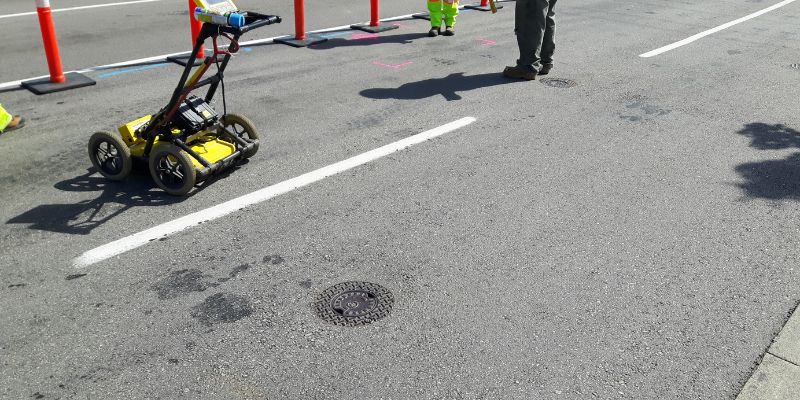
Before mapping begins, underground utilities must first be located using specialized equipment such as:
·Electromagnetic utility locators
·Ground Penetrating Radar (GPR)
·Signal transmitters
·Utility tracing equipment
These technologies help technicians identify buried utilities without excavation.
Step 2: GPS Data Collection
Once utilities have been located, survey-grade GPS equipment records the exact position of each utility feature, including:
Pipe routes
Cable alignments
Valves
Manholes
Utility access points
Junction boxes
Transformers
Each point receives accurate geographic coordinates.
Step 3: Data Verification
Technicians verify measurements to ensure maximum accuracy and consistency.
Quality assurance is essential for creating dependable utility records.
Step 4: Digital Mapping
The collected GPS data is imported into professional software where it becomes:
GIS maps
CAD drawings
Utility databases
Asset management systems
Engineering plans
These digital records become valuable resources for future maintenance, construction, and infrastructure planning.
3. Benefits of GPS Utility Mapping
GPS utility mapping provides numerous advantages for contractors, municipalities, engineers, and facility managers.
Improved Accuracy
One of the biggest advantages is precision.
Instead of relying on outdated records or estimates, GPS utility mapping provides exact locations of underground assets.
Accurate information minimizes guesswork and improves project planning.
Enhanced Safety
Excavating without knowing what's underground can lead to dangerous accidents involving:
Gas leaks
Electrical strikes
Water main breaks
Communication outages
GPS utility mapping helps crews avoid these hazards by clearly identifying utility locations before digging begins.
Reduced Project Delays
Unexpected utility conflicts are one of the leading causes of construction delays.
Knowing utility locations in advance allows teams to:
Plan excavation routes
Avoid redesigns
Prevent emergency repairs
Keep projects on schedule
Lower Construction Costs
Damaging underground utilities often leads to expensive emergency repairs, equipment downtime, labor costs, and project interruptions.
Accurate utility mapping reduces these unnecessary expenses.
Better Asset Management
Municipalities and facility owners benefit from having permanent digital records of underground infrastructure.
These records simplify:
Maintenance planning
Future upgrades
Utility inspections
Emergency response
Easier Project Planning
Engineers and designers can create better site plans when underground utilities are accurately mapped.
This minimizes conflicts during construction.
4. Industries That Depend on GPS Utility Mapping
GPS utility mapping supports nearly every industry involved in land development and infrastructure.
Construction Companies
Construction teams use GPS utility mapping before:
Excavation
Foundation work
Utility installation
Road construction
Knowing utility locations reduces project risks.
Civil Engineering Firms
Engineers rely on accurate underground utility data when designing:
Highways
Commercial buildings
Residential developments
Utility corridors
Accurate information improves design efficiency.
Municipal Governments
Cities use GPS utility mapping to manage:
Water systems
Sewer infrastructure
Stormwater networks
Public utilities
Digital mapping improves long-term infrastructure management.
Industrial Facilities
Manufacturing plants rely on GPS utility mapping to safely install new equipment and underground services without disrupting existing operations.
5. Best Practices for Successful GPS Utility Mapping
To maximize the value of GPS utility mapping, it's important to follow proven best practices.
Perform Utility Locating First
GPS cannot detect buried utilities on its own.
Utilities should first be identified using professional locating equipment before GPS coordinates are recorded.
Use Survey-Grade GPS Equipment
Consumer-grade GPS devices lack the accuracy required for underground utility mapping.
Professional survey-grade equipment provides significantly more precise results.
Verify Existing Utility Records
Historical drawings and as-built plans should be compared with field findings.
Many older utility records contain inaccuracies due to undocumented changes over time.
Update Maps Regularly
Infrastructure changes frequently.
Whenever utilities are added, relocated, or removed, digital utility maps should be updated to maintain accuracy.
Work with Experienced Professionals
GPS utility mapping requires expertise in:
Utility locating
Surveying
GPS technology
GIS mapping
Data management
Professional technicians ensure reliable results.
6. Why Choose On The Mark Locators for GPS Utility Mapping
Choosing the right utility mapping company directly impacts project success.
At On The Mark Locators, we provide professional GPS utility mapping solutions designed to improve safety, reduce project risks, and deliver accurate underground utility data you can trust.
Our experienced team uses advanced locating technology and high-precision GPS equipment to accurately identify and document underground infrastructure for projects of all sizes.
Clients choose On The Mark Locators because we offer:
Accurate GPS utility mapping services
Advanced underground utility locating technology
Highly trained and experienced technicians
Reliable digital utility mapping
Fast turnaround times
Comprehensive documentation
Safety-focused project support
Customized solutions for residential, commercial, municipal, and industrial projects
Our goal is to help clients make informed decisions while protecting underground infrastructure and keeping projects moving forward without unnecessary delays or costly utility strikes.
Whether you're planning a new construction project, managing existing infrastructure, or preparing for excavation, On The Mark Locators delivers dependable GPS utility mapping services that support smarter planning and safer operations.
Conclusion
As construction projects become more complex and underground infrastructure continues to expand, accurate utility information has never been more important. GPS utility mapping provides the precision needed to identify buried utilities, reduce excavation risks, improve worker safety, and support efficient project planning.
From construction companies and engineers to municipalities and facility managers, organizations across many industries rely on GPS utility mapping to protect underground assets and avoid costly surprises. Accurate digital utility maps streamline maintenance, simplify future expansions, and enhance long-term infrastructure management.
Partnering with a trusted provider ensures that your project is backed by dependable data and industry expertise. On The Mark Locators combines advanced locating technology, high-accuracy GPS equipment, and experienced professionals to deliver reliable mapping solutions tailored to your needs.
If you're planning excavation, construction, or infrastructure improvements, investing in professional GPS utility mapping is one of the smartest decisions you can make. With On The Mark Locators as your partner, you can move forward with confidence, knowing your project is built on accurate information, enhanced safety, and greater operational efficiency.