Underground Utilities Mapping Explained: Why Every Construction Project Needs It
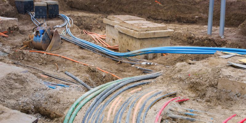
Every successful construction project begins long before excavation equipment arrives on-site. One of the most important planning steps is understanding what lies beneath the surface. Hidden underground infrastructure such as gas pipelines, electrical cables, water mains, sewer lines, telecommunications networks, and fiber optic cables can pose serious risks if they are not accurately identified before digging begins.
This is where underground utilities mapping becomes essential. It provides contractors, engineers, developers, municipalities, and utility companies with a detailed picture of existing underground assets, helping them avoid costly mistakes and dangerous accidents.
Whether you're building commercial developments, residential communities, highways, or utility infrastructure, accurate underground utilities mapping protects workers, prevents project delays, reduces repair costs, and ensures compliance with local regulations.
At On The Mark Locators, we understand that every excavation project depends on reliable utility locating and mapping services. By using advanced technologies and experienced technicians, we help clients confidently move forward with construction while minimizing unnecessary risks.
In this guide, we'll explain what underground utilities mapping is, why it matters, how it's performed, and why it should be a standard part of every construction project.
1. What Is Underground Utilities Mapping?
Underground utilities mapping is the process of locating, identifying, documenting, and recording underground infrastructure before excavation begins. Rather than relying solely on outdated utility records or assumptions, professionals use specialized equipment to accurately determine the location and depth of buried utilities.
These utilities commonly include:
Water lines
Sewer systems
Storm drainage pipes
Natural gas pipelines
Electrical power cables
Fiber optic cables
Telecommunications lines
Oil pipelines
Irrigation systems
The collected information is then organized into digital maps, CAD drawings, GIS databases, or construction plans that contractors can reference throughout the project.
Modern mapping combines several technologies, including:
Ground Penetrating Radar (GPR)
Electromagnetic locating
GPS positioning
GIS software
Digital surveying
Utility records verification
The result is a comprehensive understanding of underground infrastructure before excavation starts.
2. Why Underground Utilities Mapping Is Essential for Construction Projects
Construction projects involve excavation, trenching, drilling, grading, and foundation work. Without accurate knowledge of buried utilities, even a small digging operation can create significant problems.
Prevents Utility Strikes
Accidentally hitting a gas line, electrical cable, or water main can immediately halt a project and create dangerous working conditions. Utility strikes may result in explosions, flooding, electrical hazards, or communication outages.
Accurate underground utilities mapping significantly reduces these risks by identifying utility locations before excavation begins.
Improves Worker Safety
Construction safety begins with proper planning. Workers operating heavy machinery need confidence that excavation areas have been properly assessed.
Utility mapping minimizes exposure to:
Gas leaks
Electrocution
Fire hazards
Structural instability
Hazardous environmental conditions
Protecting workers should always be the highest priority.
Reduces Project Delays
Unexpected underground obstacles often force contractors to stop work while utilities are identified and repaired.
Mapping allows project managers to:
Plan excavation routes
Schedule equipment efficiently
Coordinate subcontractors
Avoid emergency repairs
This keeps construction schedules on track.
Saves Money
Repairing damaged utilities can cost thousands—or even hundreds of thousands—of dollars depending on the infrastructure involved.
Investing in underground utilities mapping often saves far more than it costs by preventing:
Emergency utility repairs
Equipment downtime
Labor delays
Insurance claims
Regulatory penalties
3. How Underground Utilities Mapping Works
Today's utility locating professionals use multiple technologies together to improve accuracy.
Ground Penetrating Radar (GPR)
Ground Penetrating Radar sends radio waves into the ground and measures reflections from buried objects.
GPR is highly effective for locating:
Plastic pipes
PVC conduits
Concrete structures
Unknown underground objects
Non-metallic utilities
Electromagnetic Locating
Metallic utilities carrying electrical current or conductive material are identified using electromagnetic locators.
These systems accurately detect:
Metal pipes
Electrical cables
Telecom lines
Gas mains
GPS Surveying
Once utilities are identified, GPS equipment records their exact locations.
The collected coordinates allow engineers to produce accurate construction maps that can be integrated into GIS systems.
Data Verification
Professional mapping also compares field findings with:
Existing utility records
Municipal infrastructure plans
Engineering drawings
Historical documentation
This ensures the final map is as accurate and complete as possible.
4. Industries That Benefit from Underground Utilities Mapping
Although construction is the primary user, underground utilities mapping benefits many industries.
Commercial Construction
Developers use mapping before building:
Shopping centers
Office buildings
Warehouses
Industrial facilities
Knowing utility locations reduces costly redesigns during construction.
Residential Development
Builders need accurate utility information before installing foundations, roads, driveways, drainage systems, and utility connections.
Municipal Infrastructure
Cities frequently perform utility mapping for:
Road widening
Sewer replacement
Water system upgrades
Public transportation projects
Sidewalk improvements
Energy and Utility Companies
Utility providers rely on mapping to maintain underground infrastructure and plan future expansions while minimizing service interruptions.
Telecommunications
As fiber optic networks continue expanding, accurate underground mapping helps protect existing communication lines while facilitating new installations.
5. The Risks of Skipping Underground Utilities Mapping
Some contractors attempt to save time by relying solely on old utility records or visible surface indicators. Unfortunately, these records are often incomplete or outdated.
Skipping underground utilities mapping can lead to serious consequences.
Costly Utility Damage
Damaging underground infrastructure may require:
Emergency repair crews
Replacement materials
Project shutdowns
Traffic control
Environmental cleanup
Repair costs can escalate quickly.
Legal Liability
Utility strikes can expose contractors and property owners to legal disputes, fines, insurance claims, and compensation for service disruptions.
Project Delays
Unexpected underground discoveries frequently require revised engineering plans and additional permits, delaying project completion.
Environmental Damage
Striking sewer or fuel lines may contaminate nearby soil or waterways, increasing cleanup costs and regulatory scrutiny.
Reputation Damage
Construction companies that repeatedly damage utilities may lose future contracts and client confidence.
6. Why Choose On The Mark Locators for Underground Utilities Mapping?
Choosing an experienced utility locating partner can make the difference between a smooth construction project and an expensive setback.
On The Mark Locators delivers dependable underground utilities mapping services designed to support safe, efficient excavation. Our team combines advanced locating technology with proven field expertise to identify underground infrastructure accurately before digging begins.
Clients trust On The Mark Locators because we offer:
Accurate underground utility locating
Advanced Ground Penetrating Radar (GPR)
Electromagnetic utility detection
Professional GPS mapping
Detailed utility documentation
Fast project turnaround
Support for projects of all sizes
Experienced, knowledgeable technicians
Commitment to safety and accuracy
From residential developments to large commercial and municipal projects, our team helps clients reduce risk, protect infrastructure, and keep projects moving forward with confidence.
Conclusion
Underground utilities mapping has become an essential component of modern construction planning. As underground infrastructure continues to grow more complex, contractors can no longer rely on outdated records or guesswork when preparing excavation sites.
By accurately identifying buried utilities before construction begins, underground utilities mapping improves worker safety, prevents costly utility strikes, minimizes project delays, supports regulatory compliance, and protects valuable infrastructure.
Whether you're planning a commercial development, infrastructure improvement, municipal project, or residential construction, investing in professional mapping services is one of the smartest decisions you can make.
At On The Mark Locators, we're committed to helping contractors, engineers, developers, and property owners build with confidence. Our advanced underground utilities mapping solutions provide the accuracy and reliability needed to keep projects safe, efficient, and on schedule.
Before your next excavation project begins, partner with On The Mark Locators to ensure you know exactly what's beneath the surface.